

 |
|
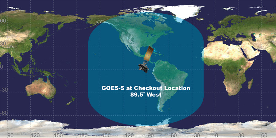
GOES-S view of Earth from its checkout location. Credit: NOAA
|
Ken Kremer — SpaceUpClose.com — 14 Mar 2018
KENNEDY SPACE
CENTER, FL – Less than 2 weeks after the
dinnertime blastoff of the GOES-S weather observatory put on a stunningly
delicious launch display from the Florida Space Coast on March 1, 2018, the revolutionary
satellite that will track extreme weather in near real time reached geostationary
orbit and was renamed as GOES-17.
“On March 12, GOES-S executed its final liquid apogee
engine burn, placing the satellite in geostationary orbit 22,236 miles away,” NOAA
announced in a statement.
engine burn, placing the satellite in geostationary orbit 22,236 miles away,” NOAA
announced in a statement.
“GOES-S
is now GOES-17!”
is now GOES-17!”
GOES-17 will revolutionize
weather forecasting in the Western Hemisphere orbiting some 22,200 mi (35800 km) above Earth where it
will operate for the remainder of its planned 15 year lifetime.
weather forecasting in the Western Hemisphere orbiting some 22,200 mi (35800 km) above Earth where it
will operate for the remainder of its planned 15 year lifetime.
The
5.5 ton school bus sized probe will provide vastly improved
forecasts and warnings on weather, wildfires, tornadoes and cyclones for
California and the western United States all the way out to Hawaii and Guam in
ways that will positively impact the lives of everyday people as well as save
lives by helping pinpoint outbreaks of severe weather in near real time.
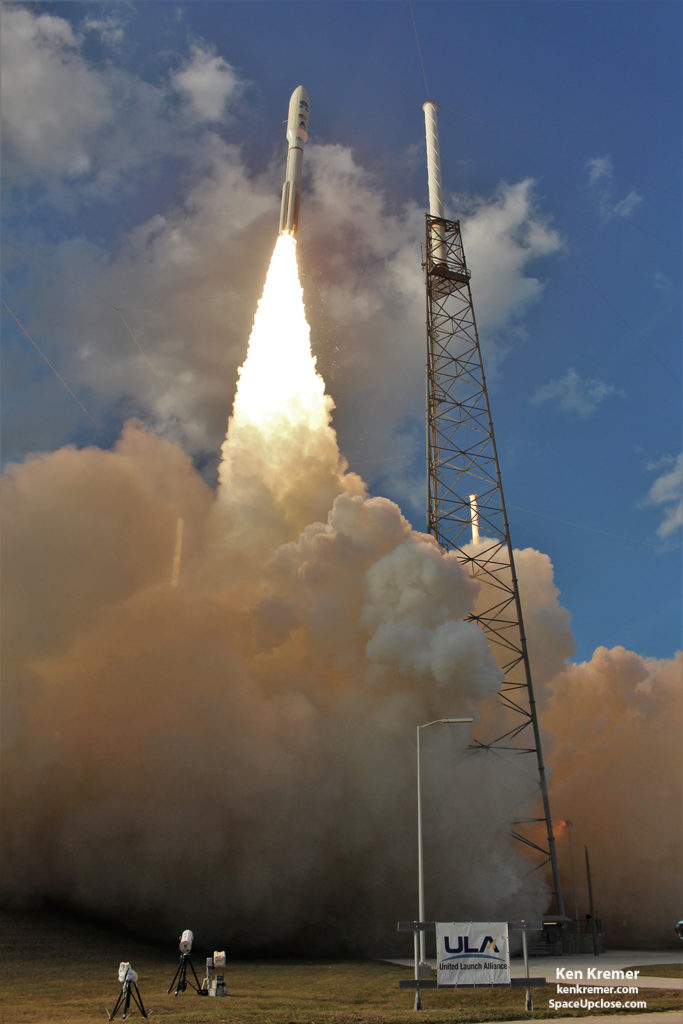
The Geostationary Operational Environmental
Satellite-S (GOES-S) lifted off on a United Launch Alliance (ULA) Atlas V
rocket from seaside Space Launch Complex 41 at Cape Canaveral Air Force Station
in Florida at 5:02 p.m. EST
on March 1, 2018.
Satellite-S (GOES-S) lifted off on a United Launch Alliance (ULA) Atlas V
rocket from seaside Space Launch Complex 41 at Cape Canaveral Air Force Station
in Florida at 5:02 p.m. EST
on March 1, 2018.
 |
|
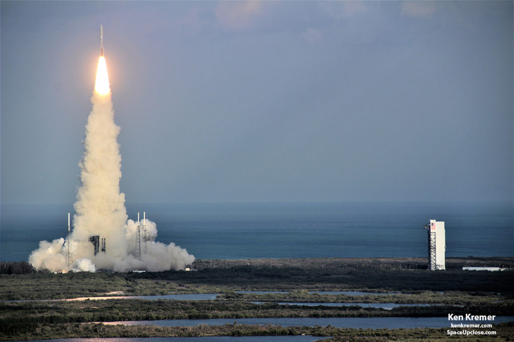
ULA Atlas V rocket lifts off from Space Launch
Complex 41 at Cape Canaveral Air Force Station carrying the NOAA/NASA Geostationary Operational Environmental Satellite, or GOES-S at 5:02 p.m. EST on March 1, 2018. – as seen from the VAB roof. GOES-S will be stationed over the western US. Credit: Ken Kremer/SpaceUpClose.com/kenkremer.com |
With GOES-17 now
in geostationary orbit, the next steps are to complete the deployment of the
solar array and solar pointing platform
and maneuver the satellite to its checkout position at 89.5
degrees West longitude.
in geostationary orbit, the next steps are to complete the deployment of the
solar array and solar pointing platform
and maneuver the satellite to its checkout position at 89.5
degrees West longitude.
A
six-month checkout of its suite of six state-of-the-art science observing instruments and space
craft systems will commence on March 26.
six-month checkout of its suite of six state-of-the-art science observing instruments and space
craft systems will commence on March 26.
NOAA
says the first images are expected in mid-May.
says the first images are expected in mid-May.
Thereafter it will be moved to its operational
location at 137 degrees West longitude in late 2018 and become NOAA’s new GOES
West observatory – thereby replacing the current
legacy satellite.
location at 137 degrees West longitude in late 2018 and become NOAA’s new GOES
West observatory – thereby replacing the current
legacy satellite.
An operational GOES-17
will complete NOAA’s constellation of two next-generation geostationary
satellites for the Western Hemisphere.
will complete NOAA’s constellation of two next-generation geostationary
satellites for the Western Hemisphere.
GOES-17 joins twin sister GOES-16 which was
the first in the series of US next-gen weather observatories and recently became
operational as NOAA’s new GOES-East observatory at 75 degrees West longitude.
the first in the series of US next-gen weather observatories and recently became
operational as NOAA’s new GOES-East observatory at 75 degrees West longitude.
Together, GOES-16 and GOES-17 will keep an eye
on weather and environmental hazards from the west coast of Africa all the way
to New Zealand.
on weather and environmental hazards from the west coast of Africa all the way
to New Zealand.
 |
|
Image shows the view of Earth from the
GOES West operational position. Credit: NOAA/CIMSS |
NOAA
manages the GOES-R Series program through an integrated NOAA/NASA office at
NASA’s Goddard Space Flight Center in Greenbelt, Maryland.
manages the GOES-R Series program through an integrated NOAA/NASA office at
NASA’s Goddard Space Flight Center in Greenbelt, Maryland.
GOES-S/GOES-17 and
GOES-R/GOES-16 were built by prime contractor Lockheed Martin Space Systems,
Littleton, Colorado.
GOES-R/GOES-16 were built by prime contractor Lockheed Martin Space Systems,
Littleton, Colorado.
GOES-17 will deliver
a quantum leap in weather forecasting for the western United States just as
GOES-R – the first satellite in the new series – is now doing for the eastern
United Stated since it only recently became operational in December 2017.
GOES-17 will provide faster, more accurate,
and more detailed data in near real-time to track storm systems, lightning,
wildfires, coastal fog, and other hazards that affect the western U.S., Hawaii
and Alaska.

The gigantic school bus sized satellite measures 6.1 m x 5.6 m x 3.9 m (20.0 ft x 18.4 ft x
12.8 ft) with a three-axis
stabilized spacecraft bus.
and more detailed data in near real-time to track storm systems, lightning,
wildfires, coastal fog, and other hazards that affect the western U.S., Hawaii
and Alaska.
“GOES 17 will become operational in the fall of 2018, “ Tim Walsh, acting GOES-R
system program director at NOAA told Space UpClose during an
interview at KSC. “It will give us the equivalent perspective for the western
US that we now have for the eastern US using the six onboard instruments namely
ABI and GLM, SUVI, EXIS, SEIS and the magnetometer.”
system program director at NOAA told Space UpClose during an
interview at KSC. “It will give us the equivalent perspective for the western
US that we now have for the eastern US using the six onboard instruments namely
ABI and GLM, SUVI, EXIS, SEIS and the magnetometer.”
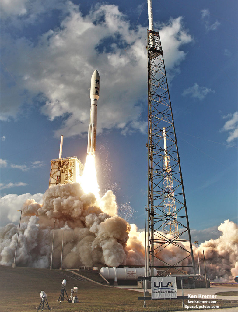 |
| A United Launch Alliance Atlas V rocket lifts off from Space Launch Complex 41 at Cape Canaveral Air Force Station carrying the NOAA/NASA Geostationary Operational Environmental Satellite, or GOES-S at 5:02 p.m. EST on March 1, 2018. Credit: Ken Kremer/SpaceUpClose.com/kenkremer.com |
GOES-S is the second in the new
GOES-R series of America’s most powerful and most advanced next generation geostationary weather observation
satellites. It is designed to last for a
15 year orbital lifetime and will deliver a ‘quantum leap’ in weather
forecasting.
GOES-R series of America’s most powerful and most advanced next generation geostationary weather observation
satellites. It is designed to last for a
15 year orbital lifetime and will deliver a ‘quantum leap’ in weather
forecasting.
GOES-S will work in tandem with twin
sister satellite GOES-R which was successfully launched by a ULA Atlas V on Nov. 19, 2016.
sister satellite GOES-R which was successfully launched by a ULA Atlas V on Nov. 19, 2016.
Altogether
the GOES-R series consists of a quartet of four
identical satellites – comprising GOES-R, GOES-S, GOES-T and GOES-U – manufactured at an overall cost of about $11 Billion. This will keep the GOES satellite system operational through 2036.
the GOES-R series consists of a quartet of four
identical satellites – comprising GOES-R, GOES-S, GOES-T and GOES-U – manufactured at an overall cost of about $11 Billion. This will keep the GOES satellite system operational through 2036.
The GOES-R series (including GOES-S)
state-of-the-art
science instrument suite includes the Advanced Baseline Imager (ABI), Geostationary Lightning Mapper (GLM),
Solar Ultraviolet Imager (SUVI), Extreme Ultraviolet and X-Ray Irradiance
Sensors (EXIS), Space Environment In-Situ Suite (SEISS), and the Magnetometer
(MAG).
state-of-the-art
science instrument suite includes the Advanced Baseline Imager (ABI), Geostationary Lightning Mapper (GLM),
Solar Ultraviolet Imager (SUVI), Extreme Ultraviolet and X-Ray Irradiance
Sensors (EXIS), Space Environment In-Situ Suite (SEISS), and the Magnetometer
(MAG).
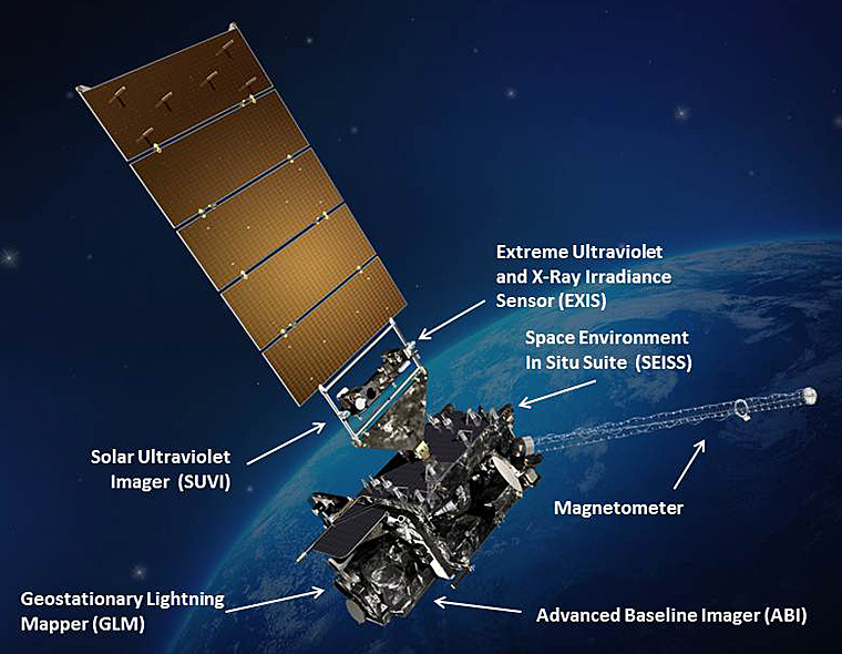
ABI is the
primary instrument and will collect 3
times more spectral data with 4 times greater resolution and scans 5 times
faster than ever before – via the primary Advanced Baseline Imager (ABI)
instrument – compared to the current GOES satellites.
primary instrument and will collect 3
times more spectral data with 4 times greater resolution and scans 5 times
faster than ever before – via the primary Advanced Baseline Imager (ABI)
instrument – compared to the current GOES satellites.
ABI views the earth with 16 spectral
channels in the visible, near infrared and infrared channels compared to 5 for the
legacy GOES satellites.
channels in the visible, near infrared and infrared channels compared to 5 for the
legacy GOES satellites.
“We are seeing a revolutionary step forward in performance
with 4x better spatial resolution, 3 x as many frequencies or spectral bands,
and we receive images 5 x faster,” Walsh said already with GOES-R/GOES-16
compared to the legacy GOES East/West satellite imager technologies “which were
created and developed in the mid-1980s.”
with 4x better spatial resolution, 3 x as many frequencies or spectral bands,
and we receive images 5 x faster,” Walsh said already with GOES-R/GOES-16
compared to the legacy GOES East/West satellite imager technologies “which were
created and developed in the mid-1980s.”
“Currently to do a full western hemisphere image with the
current imager on orbit today takes 26 minutes. With GOES-R now we can do the
same thing in 5 minutes.”
current imager on orbit today takes 26 minutes. With GOES-R now we can do the
same thing in 5 minutes.”
“So it gives us much better severe weather forecasting and
now weather forecasting imagery.”
now weather forecasting imagery.”
“We hope to start test imaging with GOES-S by around early
May, said Walsh. “First we need to raise the temperature of the instruments
once on orbit. We will outgas them for several weeks.”
May, said Walsh. “First we need to raise the temperature of the instruments
once on orbit. We will outgas them for several weeks.”
“There is no real difference between this spacecraft
GOES-S/GOES 17 and GOES-R/GOES 16.”
GOES-S/GOES 17 and GOES-R/GOES 16.”
But they will be located at different positions in the
equatorial belt to obtain different views.
Together they will be able to image the entire US and regions further
out beyond to the east and west to provide coverage of the entire Western
Hemisphere.
equatorial belt to obtain different views.
Together they will be able to image the entire US and regions further
out beyond to the east and west to provide coverage of the entire Western
Hemisphere.
“GOES 17 will provide imagery that will complement what we
have from GOES 16.”
have from GOES 16.”
“GOES S will be located at 137 degrees west longitude over
the eastern pacific. So at that time we will be able to see the entire United
States out to Hawaii, Alaska and even almost to New Zealand.”
the eastern pacific. So at that time we will be able to see the entire United
States out to Hawaii, Alaska and even almost to New Zealand.”
“GOES-R/GOES 16 is located at 75 degrees west longitude
gives the full Eastern seaboard and CONUS [continental US] coverage,” Walsh
explained.
gives the full Eastern seaboard and CONUS [continental US] coverage,” Walsh
explained.
Video Caption: This animation depicts the
areas of the Earth viewed by GOES East and GOES West from their vantage point
22,236 miles above the equator. NOAA maintains a two-satellite Geostationary
Operational Environmental Satellite (GOES) constellation to watch over the
Western Hemisphere. The satellites circle the Earth in geosynchronous orbit,
which means they orbit the Earth’s equatorial plane at a speed matching the
Earth’s rotation. This allows them to stay in a fixed position in the sky,
remaining stationary with respect to a point on the ground. Credit: NOAA/NASA
The gigantic school bus sized satellite measures 6.1 m x 5.6 m x 3.9 m (20.0 ft x 18.4 ft x
12.8 ft) with a three-axis
stabilized spacecraft bus.
It has a dry mass of 2,857 kg (6,299 lbs) and a fueled mass of 5,192 kg
(11,446 lbs) at launch.
(11,446 lbs) at launch.
 |
| A United Launch Alliance Atlas V rocket lifts off from Space Launch Complex 41 at Cape Canaveral Air Force Station carrying the NOAA/NASA Geostationary Operational Environmental Satellite, or GOES-S at 5:02 p.m. EST on March 1, 2018. Credit: Ken Kremer/SpaceUpClose.com/kenkremer.com |
Watch this
GOES-East Full Disk GeoColor satellite imagery GIF,
March 14, 2018:
GOES-East Full Disk GeoColor satellite imagery GIF,
March 14, 2018:
Watch for Ken’s continuing onsite coverage of NASA, SpaceX,
ULA, Boeing, Lockheed Martin, Orbital ATK and more space and mission
reports direct from the Kennedy Space Center and Cape Canaveral Air Force
Station, Florida.
ULA, Boeing, Lockheed Martin, Orbital ATK and more space and mission
reports direct from the Kennedy Space Center and Cape Canaveral Air Force
Station, Florida.
Stay tuned here for Ken’s continuing
Earth and Planetary science and human spaceflight news: www.kenkremer.com –www.spaceupclose.com –
twitter @ken_kremer – ken
at kenkremer.com
Earth and Planetary science and human spaceflight news: www.kenkremer.com –www.spaceupclose.com –
twitter @ken_kremer – ken
at kenkremer.com
 |
|
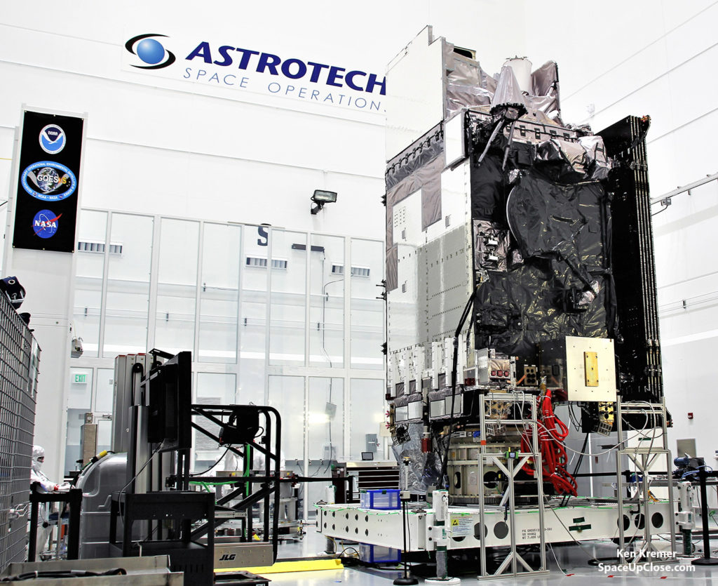
The NASA/NOAA Geostationary Operational
Environmental Satellite-S (GOES-S) is being processed in the clean room at Astrotech Space Operations, in Titusville, FL, on Jan 16, 2018 in advance of nose cone encapsulation and launch on a ULA Atlas V on Mar. 1, 2018. GOES-S belongs to new constellation of America’s most advanced weather satellites. Credit: Ken Kremer/SpaceUpClose.com/kenkremer.com |